WILDFIRE INTELLIGENCE
Multispectral aerial imagery & geospatial intelligence for rapid wildfire detection, mapping, and response
Overwatch Imaging smart sensors, thermal imaging technology and mission-specific aerial fire mapping software are trusted by agencies and responders around the world as a powerful solution for wildfire detection, monitoring and mapping. Best-in-class multispectral smart sensors deliver high value, high resolution aerial imagery. Powerful onboard processing and automation software provide ease of use and streamline data output and delivery within minutes of passing over an incident.
-
Cover vast areas rapidly, in high resolution
-
Capture up to five spectral bands simultaneously (RGB, NIR, SWIR, MWIR, LWIR)
-
Powerful edge processing enables rapid delivery of fire detection and mapping products
-
Automated data collection and processing
-
Thermal imaging enables day / night operation
-
AI-enabled detection and perimeter mapping

Smart
Multiband advantage
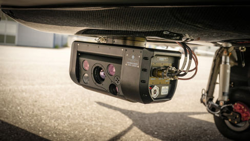
Overwatch Imaging’s TK series smart sensor payloads are packed with best-in-class thermal imaging sensors, optic, and computing technology. They’re designed to capture massive amounts of data quickly and efficiently, process the data automatically in real-time, and deliver important intelligence that drives time-critical decision making.
Wide-area, high resolution
Overwatch Imaging TK sensors image in a step-stare pattern over areas of interest. Imagery is stitched together at the edge to create detailed high-resolution mosaics of wide areas in a matter of seconds. Powerful onboard processing enables simultaneous image capture across multiple spectral bands and creates secondary lightweight data products that can be relayed with limited bandwidth.

Mapping cameras with onboard storage but no onboard processing or real-time operating environment force users to wait until after flights have concluded to work with the data. Overwatch Imaging systems analyze full-resolution multispectral imagery on the edge, in real-time, which enables immediate checks of coverage and quality while the aircraft is still in the area of interest, and data delivery during flights, or rapidly afterward.
Overwatch systems only transmit the data required or desired by real-time operators, allowing timely intelligence even in areas with poor or no communications infrastructure. This means reporting points of interest in map-format KML or shape files, cross-cueing other sensors for additional inspection, providing image chips or full-resolution raw images for in-flight download, and generating synthetic false-colored images in real time to highlight interesting content


.png)


